Caribbean · British Virgin Islands
RMS Rhone & Salt Island
An 1867 mail steamer split between 9 m and 27 m off Salt Island
Photo: Gareth Richards · CC BY 3.0
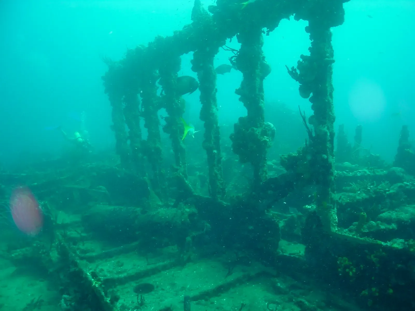
The Royal Mail Steamer Rhone was torn in half on the rocks of Salt Island by the 1867 hurricane, and the two pieces still lie where they fell. The bow section rests on its side at 24 to 27 m, intact enough to swim the length of the hull past the mast and crow's nest; the stern lies broken in 9 m, with the bronze propeller and gearbox exposed. It is the best-preserved nineteenth-century wreck in the Caribbean, and the surrounding BVI reefs are calm and easy.
About diving in RMS Rhone & Salt Island
Almost every dive here is a boat dive out of Tortola or Virgin Gorda, and the runs are short: the islands holding the sites sit across Sir Francis Drake Channel, in sight of the harbours. A morning two-tank is the standard product. The other common pattern is rendezvous diving, where a crew meets a bareboat or crewed charter yacht at the moorings and puts guests in from its own deck, which is why a lot of dive weeks here are really sailing weeks with tanks attached.
Boats pick up National Parks Trust moorings rather than anchoring, and on a busy morning you wait your turn for a ball. The ground away from the wreck is rock rather than coral wall: volcanic stone worn into boulders, ledges and swim-throughs, most of it inside 25 m, with coral and sponge growing as a crust over the structure. Shape and the light coming down through the gaps carry those dives more than colour does.
The two halves of the Rhone are normally dived in sequence on one trip, the deeper section first and the shallow one after, and that second dive can run long or, on some boats, be done at night. The wreck lies inside a marine park, so salvage and souvenir collecting are off the table and the fittings stay where they lie. The 1977 film The Deep shot its underwater sequences on the site, which did a lot for its profile.
Ground swell can close the exposed Rhone outright, most often through the Aug-Oct hurricane months, and boats move to the sheltered channel-side sites when it does. Short runs, a compact site list and a strong non-diving offer make this workable for mixed groups. The other wreck people ask about, the Kodiak Queen off Virgin Gorda, carries a widely repeated Pearl Harbor history that is hard to verify. What the BVI does not offer is ocean wall, long drift or dependable big-animal encounters.
Best time to dive RMS Rhone & Salt Island
| Jan | Feb | Mar | Apr | May | Jun | Jul | Aug | Sep | Oct | Nov | Dec | |
|---|---|---|---|---|---|---|---|---|---|---|---|---|
| Season | Prime | Prime | Prime | Prime | Good | Good | Good | Fair | Fair | Fair | Good | Prime |
| Sea surface | 27°C81°F | 26°C79°F | 26°C79°F | 27°C81°F | 28°C82°F | 28°C82°F | 28°C82°F | 29°C84°F | 29°C84°F | 29°C84°F | 29°C84°F | 28°C82°F |
| Daytime high | 27°C81°F | 27°C81°F | 27°C81°F | 28°C82°F | 28°C82°F | 29°C84°F | 29°C84°F | 30°C86°F | 30°C86°F | 30°C86°F | 29°C84°F | 28°C82°F |
| Rain | 21 mm0.8 in | 22 mm0.9 in | 19 mm0.7 in | 31 mm1.2 in | 64 mm2.5 in | 52 mm2.0 in | 59 mm2.3 in | 75 mm3.0 in | 84 mm3.3 in | 96 mm3.8 in | 98 mm3.9 in | 37 mm1.5 in |
| Jan | Feb | Mar | Apr | May | Jun |
|---|---|---|---|---|---|
| Prime | Prime | Prime | Prime | Good | Good |
| Sea surface | |||||
| 27°C81°F | 26°C79°F | 26°C79°F | 27°C81°F | 28°C82°F | 28°C82°F |
| Daytime high | |||||
| 27°C81°F | 27°C81°F | 27°C81°F | 28°C82°F | 28°C82°F | 29°C84°F |
| Rain | |||||
| 21 mm0.8 in | 22 mm0.9 in | 19 mm0.7 in | 31 mm1.2 in | 64 mm2.5 in | 52 mm2.0 in |
| Jul | Aug | Sep | Oct | Nov | Dec |
|---|---|---|---|---|---|
| Good | Fair | Fair | Fair | Good | Prime |
| Sea surface | |||||
| 28°C82°F | 29°C84°F | 29°C84°F | 29°C84°F | 29°C84°F | 28°C82°F |
| Daytime high | |||||
| 29°C84°F | 30°C86°F | 30°C86°F | 30°C86°F | 29°C84°F | 28°C82°F |
| Rain | |||||
| 59 mm2.3 in | 75 mm3.0 in | 84 mm3.3 in | 96 mm3.8 in | 98 mm3.9 in | 37 mm1.5 in |
2011–2025 averages. Sea surface: NOAA Coral Reef Watch, measured at the surface, so deeper water can run colder. Daytime high and rain: NASA POWER.
Nov–Jun is calmest and clearest; Aug–Oct hurricane season brings swell that can close the exposed Rhone site entirely.
Best months: January, February, March, April, December
BVI water temperature and weather by month
The sea surface runs from 26 °C (79 °F) in February to 29 °C (84 °F) in September. Most rain falls from July to November, peaking at about 100 mm (3.9 in) in November; it stays largely dry from January to April. Daytime highs sit around 29 °C (84 °F) all year. The coldest water here is about 26 °C (79 °F), so pack a 3 mm full suit.
Dive types & marine life
Turtles, grouper and barracuda hold on the wreck and the rock sites year-round, and eagle rays cross the sand between them. Octopus and nudibranchs are night and shallow-stern finds. There is no migration to time a trip around: what changes month to month is sea state, not the cast. Nov-Jun runs calmest, and Aug-Oct swell is what actually costs you dives.
- Wreck
- Reef
- Cave & cavern
- Night
- Sea turtles
- Groupers
- Barracuda
- Eagle rays
- Reef fish swarms
- Octopus & cuttlefish
- Nudibranchs
Best dive sites in RMS Rhone & Salt Island
Coral ridges in north-south lines with sand lanes between
Reef
Sheltered canyons and ridges off the tip of Norman Island
Pinnacle
An amphitheatre of rock, ledges and swim-throughs to 18 m
Overhangs and a gentle slope in 6 to 15 m off Cooper Island
Reef
A rocky islet between Ginger and Cooper, sloping to 30 m
Wreck
A 1988 refrigeration ship at 23 m, a long run offshore
Reef
Pillar and black coral at 21 m with pelagics passing through
Wall
A three-step wall with different growth on every ledge
A reef the length of Ginger Island's calm north side
Wreck
A 1940 Navy fuel barge under a mesh kraken, in 17 m
Reef
Sponge-painted canyons and an archway into a shallow pool
The 1867 liner's forward hull, swum at 24 m
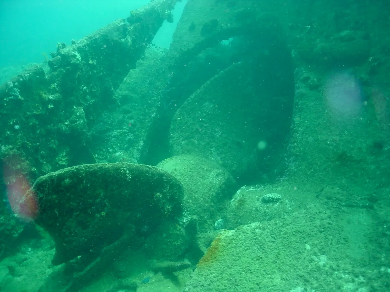
A 5 m (15 ft) propeller and open gearing in 9 m of water
Pinnacle
A pinnacle from 32 m ledges up to a 5 m reef top
Wall
A sheltered mini-wall from 5 m to 18 m under fans and sponges
Pinnacle
Four pinnacles and coral gardens, all inside 15 m
Pinnacle
A thumb-shaped rock, mostly inside 15 m, in clear water
Wreck
Four scuttled hulls on one mooring, from 20 to 27 m
How to get to RMS Rhone & Salt Island
Most divers fly into Tortola via San Juan or St Thomas, or take the ferry across from St Thomas to Road Town or the West End, an international crossing, so carry a passport. Virgin Gorda works as a base too. Every site is a boat dive, either a day trip from the dock or a pickup from a charter yacht on the park moorings.
Photos from RMS Rhone & Salt Island
Dan Schofield · CC BY 4.0
Dan Schofield · CC BY 4.0
giggel · CC BY 3.0
Joe Shlabotnik · CC BY 2.0
User:Mattes · CC BY 2.0
Dive videos
RMS Rhone Wreck Dive, British Virgin Islands · S/V AQUA on YouTube
Diving in British Virgin Islands in 2026 | Best Wrecks & How to get there · DIVEIN on YouTube
Photo credits
- Coral-encrusted iron frames of the RMS Rhone standing in a line on the seabed off Salt Island. by Gareth Richards, CC BY 3.0, via Wikimedia Commons
- A great barracuda swims past coral-encrusted pilings in the British Virgin Islands. by Dan Schofield, CC BY 4.0, via Wikimedia Commons
- A spotted porcupinefish glides over open reef in the British Virgin Islands. by Dan Schofield, CC BY 4.0, via Wikimedia Commons
- A view across Sir Francis Drake Channel to Cooper Island, Salt Island and Peter Island in the British Virgin Islands. by giggel, CC BY 3.0, via Wikimedia Commons
- Dead Chest Island seen across the water from Peter Island in the British Virgin Islands. by Joe Shlabotnik, CC BY 2.0, via Wikimedia Commons
- A dive boat with cylinders racked on deck, moored at Virgin Gorda in the British Virgin Islands. by User:Mattes, CC BY 2.0, via Wikimedia Commons
Embed
Run a dive centre, club or blog? Embed this map of 12 dive sites near BVI on your own page.
In The Logbook
- What is surge in diving, and how deep it goesOcean science · 8 min read
- Your first wreck dive: what to expect and whereFirst dives · 6 min read
Similar destinations
Swim-through rocks, a multi-level reef wall and two big wrecks
Arches, canyons and swim-throughs among the Dog Islands, a short boat ride out
Caribbean
St. John
U.S. Virgin Islands
Tarpon schools at Carval Rock and coral cays a short boat ride out


.jpg)

A Soviet frigate lies broken in two between 15 and 30 m