The tide is a wave with a strange clock
Every wave a diver meets has a period. Wind chop counts its in seconds, groundswell in tens of seconds — and the tide is the same physics stretched to planetary size: a wave whose crest is called high water, whose trough is called low water, and whose period is set by the sky. The biggest single ingredient, the principal lunar semidiurnal constituent that tide science labels M2, has a period of 12 hours 25 minutes — half a lunar day, because the Moon’s tidal bulge has two humps and the Earth turns under both while the Moon itself moves on a little. That spare 25 minutes, taken twice a day, is why the tide tables drift some 50 minutes later every day — the perfect slack you dived this morning is nearly an hour later tomorrow.
The Sun drives its own, smaller wave — S2, at exactly 12 hours. Smaller because, for all its mass, the Sun is far away: its tide-generating force works out at 46 per cent of the Moon’s. Real tides are these two plus dozens of lesser constituents, and predicting them is a per-port craft: harmonic analysis, introduced in the 1860s and still the working method, fits an amplitude and phase for each constituent from a long local record — usually more than a year of measurements for a new port. Which is the first practical lesson of the subject: tide tables are local documents. The physics is universal; the numbers never are.
Height is not stream
Divers care about two different things the tide does, and most briefing-room confusion comes from merging them. The height is how much water is over the reef — it decides whether the shore entry is a stroll or a rock scramble, and whether the top of Cathedral Rock is showing. The stream is the horizontal current the rising and falling water drives — and the stream is what pins you to a shot line or hands you a drift dive.
For the height there is a seaman’s shortcut worth knowing: the rule of twelfths. Over an idealised six-hour rise, the tide moves 1, 2, 3, 3, 2, 1 twelfths of its range in successive hours. Checked against the true sinusoid, the rule is never off by more than about a sixtieth of the range — remarkable accuracy for something you can count on your fingers. Its real message is the shape: the middle hours carry half the water. On the true curve the first hour after low moves just 6.7 per cent of the range; the mid-tide hour moves 26 per cent, nearly four times as much. Water that has to move fastest mid-tide is also, in many places, water that flows fastest mid-tide — which is exactly why slack is not just “whenever the tide turns on the height chart”.
Slack is an appointment, not a moment on the height chart
Slack water is the pause in the stream — the interval around the reversal from flood to ebb when nothing much is flowing. Where it falls relative to high and low water depends on the plumbing. In many coastal rivers and estuaries the current simply reverses with the level: NOAA’s tutorial says the slack period there “generally coincides with high or low tide”, and that it can last anywhere from seconds to several minutes. But in constricted channels connecting basins that fill and drain out of step, the stream answers to the difference in level between the two ends, not the level itself — and then slack can wander a long way from the chart. Wikipedia’s article on slack tide gives the honest extreme: at Primera Angostura in the Strait of Magellan, the ebb can keep running for up to three hours after the water level has started to rise. New Zealand’s Cook Strait goes one better, with high water at one end standing opposite low water at the other, so the strait’s currents periodically link high to low water.
Hence the second practical lesson: “slack is at high water” is a local rule, not a law. At St Abbs it happens to be true — Cathedral Rock is briefed as a slack, high-water dive. At Port Phillip Heads the window is notoriously short and hard to pick, and the operators call the dive off if the flow has not actually stopped. The only universal rule is the one your briefing already follows: the slack time comes from the local tidal-stream tables, not from the height table and not from another bay.
The window that collapses
Here is the arithmetic that decides whether your slack is leisurely or frantic. Model the stream through one tide as a sine wave peaking at U knots, and call the water diveable below half a knot — the speed at which, in DAN’s description, a diver hanging on an ascent line streams out like a flag in a 10-mile-per-hour breeze. The window around each slack then has a closed form: its length is (T/π)·asin(0.5/U). In a gentle 1-knot channel that is 124 minutes — you can dive right through slack and barely notice the tide. In a 3-knot pass it is 40 minutes: one unhurried dive, dropped on time. In an 8-knot strait it is 15 minutes, and because the asin of a small number is nearly linear, every doubling of the peak roughly halves your window. The stream you cannot dive grows; the pause you can dive shrinks from both ends.
That half-knot threshold is not bravado calibration, it is body mechanics. DAN’s current guide puts numbers on the ladder: at 1 knot, turning your head can flood your mask; at 2 knots, letting go of a line for an instant can mean being swept away. The window in the chart is the time between those regimes — and the model is the symmetric skeleton, not the site. Real channels run asymmetric, flood stronger than ebb or the reverse, and real slack arrives early or late on wind and weather. The chart tells you why the briefing is strict; the briefing tells you when.
Springs, neaps, and the fortnight rhythm
Add the Sun’s 12-hour wave to the Moon’s 12.42-hour wave and they slide slowly in and out of step, agreeing, arguing, and agreeing again every 14.77 days. When they agree — around full and new moon — the ranges swell: spring tides, with tidal streams NOAA plainly labels strong. A week later, at the quarter moons, they partially cancel: neaps, with weak streams and modest ranges. In the two-cosine skeleton the spring range is 2.7 times the neap range, and while real coastlines each stretch that ratio their own way, the rhythm itself is as dependable as the calendar — our record for the great white cage site at Edwards Island notes Foveaux Strait streams of 80 centimetres per second rising to 120 on springs, a straight spring-tide surcharge.
For divers the fortnight is a planning dial. Springs mean the strongest streams, the shortest slacks, and — since the moving water is what the animals came for — often the biggest action at the hook-in sites. Neaps mean longer windows, gentler drifts, and the forgiving week for a first pass dive or a delicate photography plan. The professionals already dive by it: the Knivestone’s rocks only bare on low-water springs, and half the UK charter calendar is written around which weekend the neaps fall on.
The places the timetable built
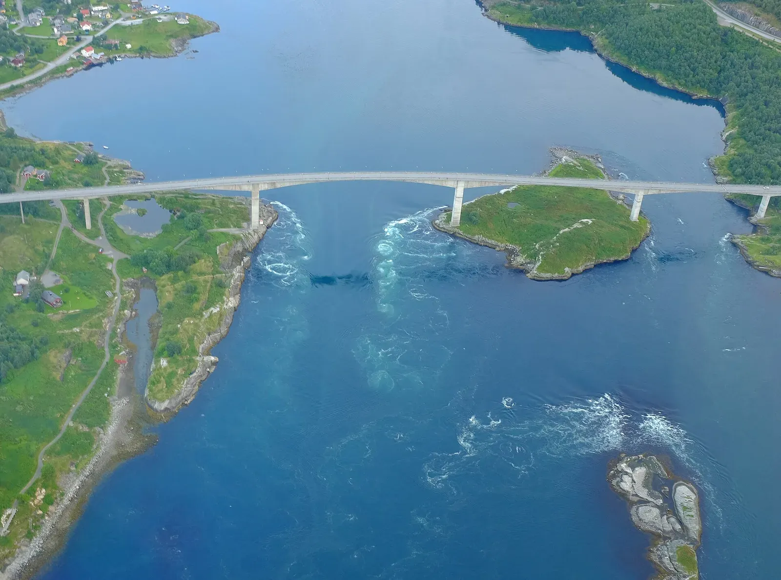
The tide’s masterpiece is Saltstraumen, the strait near Bodø that is the standard claimant to the world’s strongest tidal current: some 400 million cubic metres of seawater forced through a channel 3 kilometres long and only 150 metres wide every six hours. The often-quoted top speeds run to 40 km/h; the Norwegian Pilot’s soberer figures are about 7 knots on the inflow and over 8 on the outflow — either way, water no diver swims in. Diving there happens entirely inside the slack windows, among giant anemones and current-fed kelp, which makes it the purest expression of this whole article: a world-class site that exists, for a diver, only as an appointment.
The same timetable, in milder handwriting, builds the rest of the list. The Tuamotu and Pacific passes — Fakarava’s South Pass with its wall of 700 grey reef sharks, Yap’s Mi’il Channel where the stream swings from imperceptible to six kilometres per hour at the change, Naiqoro Passage’s spawning runs — are tidal rivers between lagoon and ocean, dived on the flow the tide schedules. The hook-in sites, Blue Corner and Big Fish Country, are dived for the stream rather than around it. And the cold-water classics — Lundy’s Knoll Pins, the Knivestone, the trimix wrecks of Malin Head dropped on shot lines at slack — are the appointment kept in a drysuit. Even the gentle end of the scale is tide-written: Bergse Diepsluis is the Oosterschelde’s easy option precisely because it sits where the tidal current barely reaches.
Where the tide runs the dive
| Site | Depth | Current | Level | Best months |
|---|---|---|---|---|
| South Pass (Tumakohua) Fakarava · French Polynesia | to 27 m | Moderate | Intermediate | Jun–Jul |
| Mi'il Channel Yap · Micronesia | 15–30 m | Moderate | Intermediate | Dec–Mar |
| Blue Corner Palau · Palau | 8–30 m | Strong | Advanced | Dec–Mar |
| Golden Passage Komodo · Indonesia | to 25 m | Strong | Advanced | Jun–Oct |
| Big Fish Country (Maratua) Derawan & Sangalaki · Indonesia | to 26 m | Strong | Advanced | Apr–Jul |
| Naiqoro Passage Kadavu & the Great Astrolabe Reef · Fiji | to 36 m | Strong | Advanced | Apr–Oct |
| Mikomoto-shima Mikomoto & Nakagi · Japan | to 35 m | Strong | Advanced | Jul–Oct |
| Cathedral Rock St Abbs & Eyemouth · United Kingdom | 3–18 m | Mild | Intermediate | Jun–Sep |
| Knivestone Farne Islands · United Kingdom | 3–20 m | Strong | Advanced | Jun–Sep |
| Knoll Pins Lundy Island · United Kingdom | 15–25 m | Moderate | Intermediate | Jun–Sep |
| HMS Audacious Malin Head · Ireland | 58–68 m | Strong | Advanced | Jun–Aug |
| Bergse Diepsluis Zeeland · Netherlands | to 19 m | None | Beginner | Apr–Jun |
| Sund Rock Puget Sound · United States | 21–24 m | Mild | Intermediate | Oct–Feb |
| Edwards Island Stewart Island · New Zealand | to 3 m | Strong | Intermediate | Dec–Mar |
| The Plateau Port Phillip · Australia | to 16 m | Strong | Advanced | May–Jul |
| Cabbage Patch Cocos (Keeling) Islands · Australia | 5–20 m | Moderate | Intermediate | Apr–Jun |
Shark TV - Fakarava, Diving the South Pass with Sharks, tons of Fish and the Famous Napolean Wrasse · underWATERcam - Your Window to the Ocean & Nature on YouTube
The tide is one of the two clocks that move dive water; waves and surge is the other, ticking in seconds instead of hours. What you do once the stream is carrying you is the drift guide’s subject; what the height does to your walk-in is scattered through the shore-diving guide; and holding a stop when the water will not sit still is covered in what a safety stop does.


